|
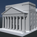
Since 1993 PHOCAD is working in the field of close-range photogrammetry and develops the digital photogrammetric system PHIDIAS. In the beginning it was mainly used for architectural drawings and documentation of historic buildings. Due to the constant improvement of camera technology and partial automation of image measurement, further areas of application came up. For example city modeling, documentation of industrial facilities, mapping of accident scenes and high precision deformation measurement.
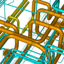
Already in 1999, when the first 3D laserscanners were used in surveying, we recognized that the combination of 3D pointclouds with high resolution images has many advantages. Consequently we extended PHIDIAS capabilities for processing of LIDAR data. Pointclouds from different sources may be used. Data from terrestrial stationary scans can be used for modeling, as well as mobile and airborne data.
The individual and flexible adaption of software to the requirements of our clients has highest priority for us.
|